Words & Photos: Otto Helberg
My friends, Malvin Eriksen (Norway) and Nathan Kesler (California), and I had just completed our first year at the Bethel School of Supernatural Ministry, in Redding, USA, and were ready to celebrate with an epic adventure.
Climbing mountains was our passion and for the past nine months we had been staring at Mount Shasta (14,179 ft), which would gain us entrance to the 14er Club if we climbed it successfully, and make a ski descent. With this in mind, we headed for Mount Shasta.
Arriving in the city of Mount Shasta, in Siskiyou County, California, we purchased the last few items of climbing equipment we would need to successfully climb this mighty mountain. Our next and last stop was the US Forest Service to buy a $20 climbing permit, which is required for all trips above 10,000 ft (3,048 m). In addition to this climbing pass, wilderness permits are also mandatory for any overnight stays in the wilderness, but this one is free, as well as pack-out bags for human waste.
The first recorded ascent of Mount Shasta occurred in 1854 by E.D. Pearce, and according to the well-known climbing forum, www.summitpost.org more than 15,000 summit attempts are made every year, but only a third are successful. The reasons for this are physical ability, rapidly changing weather conditions and a lack of preparation. Thanks to Ranger Bob, from the US Forest Service, we were armed with some valuable information about the climbing conditions and correct route to follow, and ready to conquer our mountain.
Just before we left Bunny Flats, Nathan got a call from an old fire-fighting friend, who told us that there was a front moving in after midday. It helps having a smoke jumper in your expedition team.
We set out on our alpine-style climbing adventure from the parking lot at Bunny Flats (6,950 ft – 2,118 m) at 14h30, straining against our heavily loaded packs containing enough food for a week and more than five litres of water each, as well as our skis, snowboards, boots, tents, sleeping bags and pads, cooking stove and more. However, just a minute into the hike, we had to return to the car to change a broken walking stick, make a few last-minute changes and settle the nerves.
The plan was to take the Avalanche Gulch route up to Helen Lake. It’s the most common route and easy to follow, but early on we took a wrong turn and found ourselves at the top of a hill. From our viewpoint, we could clearly see that we weren’t on the right track anymore. Retracing our steps was the last thing we wanted to do, so we decided to stay on the ridge and take the Green Butte Ridge route, which was harder and far more technical, but more suitable in snow-covered winter conditions.
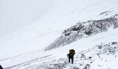
Unfortunately, this ridge was not fully covered in snow anymore, so it was extremely rocky and treacherous in some parts. We had to call on our valuable rock climbing skills to manoeuvre safely around, up, and over the big rock faces. Malvin couldn't resist skinning around the snow on his skis and met us further up the ridge. By this time, daylight was starting to fade and we were tiring, but stopping now was not an option because we had no protection from the elements and couldn't set-up camp here. Sinking knee deep into slush with every step we took, it was hard work making our way through the soft snow towards our next marker, a gully. Concentrating fully on the task at hand, I was somewhat surprised, and startled, when my right leg totally disappeared in the snow and I landed face first in the powdery snow. When I tried to pull my leg out, it wouldn't budge. Due to the steepness of the traverse, I had to be careful not to lose my pack or slide down the mountain, but with Nathan’s help, we were able to dig my leg out safely and continue on our way.
Once down in the gully, we had one final hill to conquer before reaching the base and our overnight stop. I was exhausted and it did not feel like we were getting any closer. It’s at times like these that you need to remain focused and keep any negative thoughts at bay. Thanks to my friends and their constant encouragement, I realised that we were going to make it. The sun said goodnight at 20h30, leaving behind a pristine landscape and Californian sky painted in the colours of light pink, blue, and deep red. We eventually made it to the base, at Helen Lake, just before 21h00 and hastily pitched our tents and cooked our food in the dark. It was then that I realised I'd forgotten my rooibos tea and biltong at home, which I wanted to bring so that I could share some South African culture with my international friends. It should have been the first thing in my bag!
Sleeping at 10,443 ft (3,183 m) is not easy. The temperature dropped to well below zero and our excited minds kept our fatigued bodies tossing and turning as we tried to find sleep. Throughout the night we could hear other climbers ascending from further down or getting ready to leave Helen Lake. We woke up at 05h10, so much for getting up at 03h00, and saw a line of people marching like ants up a wall. We took our time packing our bags with just the bare necessities and left the rest of our gear in the tents. The morning was chilly and the warm coffee welcome. Inhaling the fresh alpine air, we stared in awe at the mountain in front of us and finally left at 06h30.
The first milestone was Thumb Rock. We passed to the right of The Heart (12,300 ft - 3,749 m), placing one foot in front of the other in small steps, counting, thinking, dreaming, and praying our way up the challenge. Halfway up, we put our crampons on for better grip on the ice and soon got into a rhythm.
When approaching Thumb Rock, you need to veer to the left and pass through the Red Banks, also known as the ‘Bowling Alley’ because of the narrow gate for climbing traffic. In spring and summer this route is preferred over the conventional route that follows along Konwakiton Glacier, on the other side of Thumb Rock, which has now melted away and left a big crevasse in the path.
Upon reaching Thumb Rock, we stopped for a rest and once again admired the incredible vista before us. We were doing great on time and there was no sign of bad weather. The next stop was Misery Hill (13,520 ft – 4,121 m), and the name says it all. It was a long and never-ending hill. Its summit lies hidden behind Misery Hill and will only be found by those who persevere to the end.
Eventually, after a few inner victories, we made it to the top of Misery Hill and were rewarded with a view over the lower summit plateau of the mysterious Mount Shasta, just a few hundred metres in front of us. Returning climbers greeted and encouraged us on as we exchanged news on the weather conditions. After tying our bags together, we took off all our gear, grabbed some water, a snack and chocolate bar, and started sprinting towards the finish line. After the final 60-metre climb up snow and ice, we made it to the summit at 11h15 - our decision to leave our bags on Misery Hill had turned out to be key to the success of this climb. According to our friend Bob, from the Forest Service, the average time from Helen Lake to the summit is seven hours. We had completed it in under five hours.
The summit was a small rocky surface with endless views of northern California. We shared it with another group of climbers, took pictures, and signed a book to make it official. Our celebrations were cut short though, as the wind picked up and clouds started to build. It was time to leave. On the way down, we saw and smelled the area where John Muir had supposedly survived an overnight blizzard in 1877 by lying in the hot sulfur springs.
Back at Misery Hill, we changed our boots and prepared to fly down the mountain. Nathan and I were on snowboards and Malvin on skis. We got off to a shaky start due to strong gusts of wind almost sending us over the cliff, and the extra weight on our backs did not make things easier either. We found the gap in the Red Banks and this time took the route to the left of The Heart. Despite the snow being a bit icy, we were having fun and arrived back at Helen Lake in less than a half an hour. The group we had met on the summit was still nowhere to be seen. It was now 13h00 and the clouds were really moving in quickly, so we stopped for a brief rest before making our final descent.
An hour later, we finally saw the group coming down, but they still had a long way to go. While strapping down our gear, we felt drops of snowy rain falling and it was now a race against the elements. One last look up the mountain and down we went. The snow conditions were a lot better and carving for miles was way easier than having to walk down. It took us roughly 40 minutes to get back to Bunny Flats. Mission accomplished.
We'd had the privilege of walking in the park of creation and the beauty of the great American outdoors took my breath away. What is your dream? What takes your breath away? Before you run out of time, go, DO IT NOW!
FAST Facts
• Elevation: 14,179’ (4,322 m)
• Last eruption: 1786
• First ascent: 1854 by E.D Pearce
• Prominence: 9,823’ (2,994 m)
• Mountain Range: Cascade Range
Mount Shasta is an active volcano located at the southern end of the Cascade Range in Siskiyou County, California. It is the fifth highest mountain in California, the second highest mountain in the Cascade Range (Mount Rainier is 249feet higher), and the 46th highest mountain in the United States. Mount Shasta is an ultra-prominence peak with 9,822 feet (2,994metres) of prominence, making it the 96th most prominent mountain in the world and the 11th most prominent mountain in the United States.
Mount Shasta has erupted at least once every 800 years during the last 10,000 years, with its last eruption occurring in the 1780s.
Mount Shasta has seven named glaciers: Whitney, Bolam, Hotlum, Wintun, Watkins, Konwakiton, and Mud Creek. Whitney Glacier is the longest, while Hotlum Glacier is the largest glacier in California.
The origin of the name Shasta is unknown, although some think it derives from a Russian word meaning 'white'. The local Karuk Indians called it Úytaahkoo, which translates to 'white mountain'.
The first ascent by women was Harriette Eddy and Mary Campbell McCloud in 1856.
dinFO
14er - A mountain that is taller than 14,000 feet high.
