Pietermaritzburg City Hall
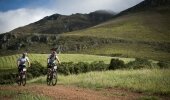
It’s time to get your bikes dusted off and start your training for KwaZulu-Natal’s premier cycle race – and with its newly announced sponsor, Tsogo Sun, it means a return to the very popular finish - the beautiful Suncoast on Durban’s Golden Mile
Time: 06h45
Finish: Suncoast, Durban
Distance: 106km with full road closure
Route Description for the Amashova Durban Classic 106km
The start is in Chief Albert Luthuli Street (Commercial Rd) outside the Pietermaritzburg City Hall
Cyclists turn Right into Alexander Rd and continue up Fox Hill onto the R103.
Cyclists turn left at R56 to Thornville via the R603 to Camperdown.
The first water point is situated outside the Thornville Chicken Farm 20kms from the start
The route continues towards the Umlaas Road intersection where the cyclists will take a hard right turn and ride under the railway bridge.
After approximately 500m the route takes a left turn onto the R103 to Camperdown.
The route will cross over the N3 into Camperdown.
The cyclists take a sharp right turn and then another sharp right about 100m further along.
The route then takes a left turn that takes them out of the Camperdown Village onto the R103.
The cyclists will take a hard right turn over the N3 again and then immediately a left at the tall gum trees and go parallel to the N3.
The cyclists go straight into Doonrug Drive at Cato Ridge.
They will turn right into Vrijheid Avenue and left into Drew Lane.
Cyclists then turn left into School Road and left into Selby Road and come out under the subway. They will turn right at the four-way stop with Dunbar Spar in front of them.
The second water point at Eskom is 40kms from the start
The race continues long the R103 through Harrisons Flats.
At R103/ Inchanga/Drummond/1000 Hills the race turns left onto the R103. (First cut off point)
The third water point is situated at the Comrades Wall of Honour 60kms into the race
The route then passes Kearsney College, where the route rapidly begins the decent with a very fast downhill section into Botha’s Hill. (Second cut off point)
The cyclists turn right into Kassier Road.
They then link up with the M13 at Shongweni where the route takes a left turn onto the M13 Highway.
The Gillitts Water Point is situated outside the Gillitts Station on the M13 approximately 80kms into the race
The cyclists continue along the M13, which includes the descent down Fields Hill
The last water point on the route is at 45th Cutting outside the Engen garage
Jan Smuts Highway ends in a sharp descent, where cyclists must turn SHARP LEFT to enter the outbound lanes of the N3 Western Freeway
They will continue along the N3 into Durban underneath the Tollgate Bridge
The route takes the cyclist down Pine Street to a left turn in Walnut Road and straight onto Masabalala Yengwa Avenue (NMR Avenue) Southbound
Cyclists will turn right into Battery Beach Road
Cyclists will travel under the M4 bridge
Then right onto Suncoast Boulevard contra-flow
The finish banner will be outside the Suncoast Towers entrance
Cyclists will ride on to the Sundeck to enjoy post event activities
Route Description for the Amashova 65km Half Challenge
Cyclists start in Drew Road in Cato Ridge at 05h30
They will turn left into School Road
They will turn left into Selby Road and come out under the subway. They will turn right at the four-way stop with Dunbar Spar in front of them.
The first water point outside Eskom
The race continues long the R103 through Harrisons Flats.
At R103/ Inchanga/Drummond/1000 Hills the race turns left onto the R103. (First cut off point)
The second water point is situated at the Comrades Wall of Honour
The route then passes Kearsney College, where the route rapidly begins the decent with a very fast downhill section into Botha’s Hill. (Second cut off point)
The cyclists turn right into Kassier Road.
They then link up with the M13 at Shongweni where the route takes a left turn onto the M13 Highway.
The Gillitts Water Point is situated outside the Gillitts Station on the M13 approximately
The cyclists continue along the M13, which includes the descent down Fields Hill
The last water point on the route is at 45th Cutting outside the Engen garage
Jan Smuts Highway ends in a sharp descent, where cyclists must turn SHARP LEFT to enter the outbound lanes of the N3 Western Freeway
They will continue along the N3 into Durban underneath the Tollgate Bridge.
The route takes the cyclists down Pine Street to a left turn in Walnut Road and straight onto Masabalala Yengwa Avenue (NMR Avenue) Southbound
Cyclists will turn right into Battery Beach Road
Cyclists will travel under the M4 bridge
Then right onto Suncoast Boulevard contra-flow
The finish banner will be outside the Suncoast Towers entrance
Cyclists will ride on to the Sundeck to enjoy post event activities
Route Description for the Amashova 35km Fun Ride
Start outside Lillies Quarter in Old Main Road, Hillcrest at 05h30
Travel along Old Main Road and then take the left glide off onto the M13.
The Gillitts Water Point is situated outside the Gillitts Station on the M13.
The cyclists continue on the M13, down Fields Hill.
Please take care going down Fields Hill, slower cyclists must remain on the left hand side.
The last water point on the route is at 45th Cutting outside the Engen garage
Jan Smuts Highway ends in a sharp descent, where cyclists must turn SHARP LEFT to enter the outbound lanes of the N3 Western Freeway
They will continue along the N3 into Durban underneath the Tollgate Bridge.
The route takes the cyclist down Pine Street to a left turn into Walnut Road and straight onto Masabalala Yengwa Ave (NMR Avenue) Southbound
Cyclists will turn right into Battery Beach Road
Cyclists will travel under the M4 bridge
Then right into Suncoast Boulevard contra-flow
The finish banner will be outside the Suncoast Towers entrance
Cyclists will ride on to the Sundeck to enjoy post event activities