
- Magazine
- #readityourway
- Weekly Stories
- #shareyourstory
-
Adventure
- Abroad Travelling
- Africa Travelling
- Events
- Expos & Shows
- Festivals
- Fishing
- Free Diving
- Gliding
- Horse Riding
- Inspiring People
- Islands Travelling
- Kite/Windsurfing
- Motorbiking
- Motorised Water Sports
- Mountaineering
- Mountain Biking
- Off-road 4x4
- Off-road Motorbiking
- Paddling
- Performance Driving
- Photography
- Rock Climbing
- Rollerblading
- Sailing
- Scuba Diving
- Skateboarding
- Skydiving
- Snowboarding & Skiing
- Surfing
- Swimming
- Trail Running
- Wakeboarding
- Waveski Surfing
-
Sport
- Adventure Racing
- Fishing
- Free Diving
- Gliding
- Health & Fitness
- Horse Riding
- Inspiring People
- Kite/Windsurfing
- MMA
- Motorbiking
- Mountain Biking
- Multi-sport
- Off-road 4x4
- Off-road Motorbiking
- Paddling
- Performance Driving
- Photography
- Road Cycling
- Road Running
- Rock Climbing
- Rollerblading
- Sailing
- Scuba Diving
- Skateboarding
- Skydiving
- Snowboarding & Skiing
- Surfing
- Swimming
- Rugby
- Trail Running
- Triathlon
- Wakeboarding
- Waveski Surfing
- Lifestyle
- Calendar
Take a Hike
Words: Cheryl Whelan ǀ Photos: Sean Smith
Category:
Hiking
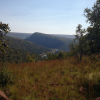
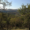
A mere 120 km from Pretoria lies one of nature's best kept secrets - the Olifants Gorge. The hiking trails here traverse an area of 15,000 hectares at the confluence of the Olifants and Wilge Rivers, near Loskop Dam.
The trail network is composed of routes that can easily be hiked as a day trail or for the more advanced, can be combined into overnight trails, with comfortable lodging at different locations.
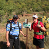
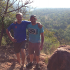
Being an active and fit person and always keen to take on a challenge, I opted for the two-and-a-half-day trail. Arriving the night before the start of our hike, four of my friends and I stayed over at Slaghoek House, which is also the start of the trail. It's a large thatch-roof farmhouse, with five bedrooms and two bathrooms, and is surrounded by a large garden that is the base of a very scenic but steep cliff. The outdoor braai area and a big patio are perfect for those relaxed star-gazing evenings.
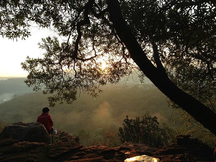
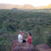
There are two trails that can be done from Slaghoek House; the God’s Window loop and Cycad loop. With our 20 kg backpacks filled to the brim, with day snacks, meals, clothes, toiletries and sleeping bag, we decided to start off from the God’s Window loop at 9.30 a.m. A gentle climb took us to a viewpoint high above the Olifants River, with steep cliffs descending far below and hundreds of hills in the distance. We took a few minutes to marvel over the stunning scenery, and agreed how lucky we were not to be sitting in the office and rather enjoying the beauty of nature.
Our first test was to hike safely to the bottom of the gorge, along a well-marked but densely wooded and rocky trail.
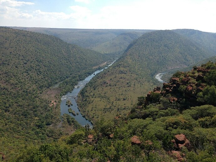
On a few occasions the backpacks had to come off so that we could negotiate over the rocks without worrying about taking a fall. However, the view of the gorge was spectacular and soon took our minds off this difficult and gnarly route. We eventually reached Snaaksekraans, a spot next to the river and from where we could see the overhanging cliff that we had been on just a few hours prior.
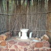
The next stop was Klipcamp and where we would have lunch. To get there, the trail meandered alongside the river for a short time before heading toward another steep climb. A very rocky and demanding descent awaited us before we eventually reached Klipcamp; four hours from when we started our hike that morning. Klipcamp is nestled between huge rocks that blend in well with the surrounding red cliff faces, just above the river. There is a spacious braai and under-cover dining area and kitchen, which can accommodate 20 people.
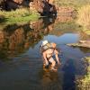
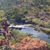
After lunch, we continued toward Kingdom, our overnight stop. The trail on this route was disappointingly not well marked and created plenty of doubt with regards to whether we were going in the right direction. After some searching, we were reunited with the route marker that also came with our first river crossing. This consisted of approximately 15 m of slippery rocks and small rapids, so you had to make sure that every step taken was on a secure and non-slippery rock as the water was too deep to step onto the river bed.
The river was not necessarily dangerous, however, one wrong step could see you swimming a short distance downstream with the current, and hiking in wet clothes for the next few hours would not would not be too comfortable.
Once everyone had made it across the river, we headed upstream and to yet another steep climb. By the time we reached the plateau at Bamboes Kloof, it was 5 p.m. and evening dusk had started to creep in. We had to decide if we would continue on this 4 km route to Kingdom or take the more secure 2 km route to Grootdraai Hut which we could see in the distance. We chose to stick with our original plan and took the 4 km route to Kingdom, with just one hour of light left to light our way. It was literally a climb and a decent, but due to the path being covered with uneven stones, we had to negotiate carefully before reaching the gorge and a welcom flat surface.
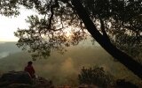
After nine hours of hiking and an approximate distance of 25 km travelled, we eventually located our overnight stop at 6.30 p.m. The chalets here where exceptionally well maintained and had a communal kitchen and bonfire area, which we made good use of. It didn't take long to heat up the 'donkey' for some warm shower water, after which we relaxed in front of the fire and listened to the baboons chattering in the distance, and the gurgling water from the Wilge River Camp below us.
On day two, we left Kingdom at 9 a.m. and had a choice of two routes to take. We opted for the Snaaksekrans loop that was 13 km longer and had two river crossings, as it was the more challenging of the two trails. This route started off with an easy walk between the hills, but as we continued towards the river and made our way alongside it, the hike turned into a difficult rock climbing session over big boulders. The sounds of the rapids below kept us focused and going until we came to flattish section of the rocks for a much-deserved coffee break.
Our first river crossing took us quite a bit of time to cross, as we tried to find the best possible route to avoid the slippery and sharp rocks and slight rapids in our path.
The fresh, cool water was a blessing though after the tough morning of boulder climbing. Once we reached the other side of the Olifants River, we found ourselves on the same path we had used the day before and knew exactly what to expect from the rest of the route.
Passing the intersection of Kingdom and Grootdraai once more, we then turned down the 2 km Grootdraai route, where a very steep decent lay in wait for us. With the light starting to fade, we arrived at Grootdraai Hut after setting out 8.5 hours earlier. It's a rustic hut with three walls situated above a series of large pools and rapids in the Olifants River and offers the most breathtaking views over a small island in the river. Grootdraai Hut, which derives its name from the Olifants River’s wide circle, 'groot draai', below the camp. Ablutions consisted of a 'long drop' that overlooked the gorge and a bucket to be used for a bath.
For the last day of our hike, it was decided that we would complete the short 6 km route back to Slaghoek. The sharp decent continued from where we left off as we made our way into the gorge and to our last river crossing. We crossed with ease and managed to pick up the pace over the first 3 km flat section. Sadly, this was short lived as yet another steep hill appeared in front of us, so we had to do a bit of mountaineering up the rocks and carefully negotiate around trees. Heart rates surged and sweat dripped from our faces, but we eventually made it to the top and the flat terrain of the Cycad route and grass-covered valley.
As we made our way to what we thought was the home stretch, it dawned on us that we had been walking for a longer period than we had planned.
Having a look at the map, and much to our disappointment, it was apparent that we missed our turn off and were on the 11 km Cycad Route and our hearts sank. This longer route took us through a natural stream that cascaded down numerous waterfalls, and our 'boulder' hiking was about to begin once more, but on a much bigger scale and definitely not for the novice hiker. The trail just never seemed to end, but this was mostly due to frustration and tiredness, and what should have been just two-and-a-half hours to the end of trail turned into a five-hour event. We most probably would have enjoyed it more if we were not pushing to get to the finish so that we could get back to Johannesburg.
The Olifants Gorge hike will be remembered for its stunning scenery from overhanging cliffs and the river crossings, as well as the well kept and clean accommodation.
I would classify it as a difficult hike because it is a hike with a few big and steep inclines, as well as some moderate scrambling on rocky paths and off the paths.
|
|
|
|
|
|
|
|
|
|
|
|
|


Current Issue

Issue 28 Aug 2013
Latest News

Fri, 09/08/2013 - 07:30

Fri, 09/08/2013 - 07:30
Enter & WIN!
Enter your name and email address below and stand a chance to win 1 of 2 Scuba-Licious Open Water courses worth R2 200 EACH